Success Story
Project Focus: Airspace Monitoring, Drone Industry
In a world characterized by the increasing presence of drones, a client of ours needed a groundbreaking solution that addressed the challenges of airspace monitoring, flight planning, and compliance in the drone industry. With the proliferation of unmanned aerial vehicles (UAVs) and the complexity of airspace management, we designed a solution for them that offers a comprehensive, intelligent, and an all-in-one platform to empower drone operators. This case study explores the use case and functionalities of this solution.
As the skies are becoming increasingly crowded with drones, the need for an intelligent, all-in-one solution to monitor airspace, strategize and carry out flights, and collect valuable insights is paramount. Drone operators face numerous challenges in ensuring the secure and compliant execution of their missions, especially with evolving airspace regulations and environmental factors. Our client wanted a solution that solves this complex issue.
By leveraging revolutionary technology that utilizes airspace awareness, weather intelligence, and autonomous flight operations to execute and facilitate secure and self-guided drone flights we enabled the client to overcome the challenge of airspace monitoring.
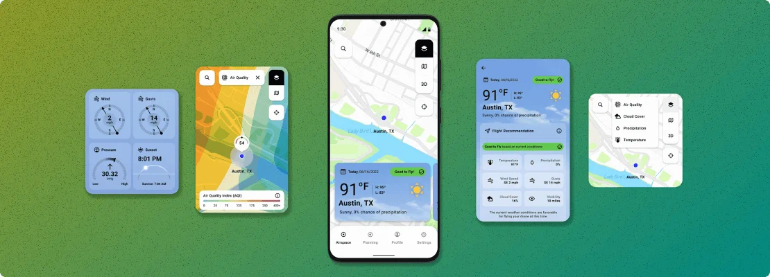
It constantly observes, anticipates, and adapts to changes in airspace activity, environmental conditions, and vehicle capabilities, ensuring safe and compliant operations.

It provides flight recommendations based on advanced weather features such as cloud cover, wind speed, wind direction, and more, using industry-recommended values for safe drone flights.
Users can view different weather layers and map layers to assess current weather conditions and traffic, enabling informed decision-making before initiating a flight.
Users can view different weather layers and map layers to assess current weather conditions and traffic, enabling informed decision-making before initiating a flight.
Users can create waypoint-based or exploration-based objectives to plan their flights. These plans can be executed immediately or saved for future flights.
Operators can set various parameters for each objective and the overall flight, including flight speed, altitude, and actions upon mission completion.
The application simplifies airspace exploration and automates flight missions, allowing for the autonomous execution of pre-defined flight plans.
The user-friendly interface empowers drone operators to streamline their missions, reducing the need for manual intervention and enhancing the efficiency of drone operations.
Users can access flight recommendations based on advanced weather data, ensuring safe drone flights.
Users can view different weather layers on maps, enabling them to make informed decisions based on current weather conditions and traffic.
The app provides real-time information about airspace restrictions and NOTAMs to ensure compliance with guidelines.
Users can create waypoint-based or exploration-based objectives, offering flexibility in flight planning.
Operators can set various parameters for each flight objective, including flight speed, altitude, and actions upon mission completion.
This cutting-edge solution offers a holistic approach to overcome the hurdles encountered by drone operators when it comes to airspace management, mission planning, and regulatory compliance.
Harnessing state-of-the-art technology and an intuitive interface, it enables drone operators to navigate airspace with assurance, streamline mission planning, and execute safe and efficient flights, all in alignment with ever-changing regulations and environmental considerations.
26-F, Gulberg 2,
Main Market, Lahore
6001 W Parmer
Lane Ste 370 #734,
Austin, TX 78727
Office 404, Al Saaha
Offices – B, Souk Al Bahar, Burj Khalifa District,
P.O. Box 487177, Dubai